
From the Malvern Hills on the Hereford/Worcestershire border to Skomer Island on the western tip of Pembrokeshire, the tall concrete finger pillar which stand at the highest point of any specific hill is instantly recognisable by all hiker's. The 75th anniversary since they were first introduced at the beginning of the re-triangulation of Great Britain was marked in April 2011.
On a clear, crisp spring morning in 1936, a group of men gathered around a strange, pale obelisk in the middle of an unremarkable field in Cold Ashby, Northamptonshire. Those men were there to begin the greatest undertaking Ordnance Survey had attempted since the early 19th century.

At the time Trig. Pillars were part of a state-of-the-art network built to literally re-map Britain. The re-triangulation was to prove an enormous task and lasted 26 years until 1962 (with a break for World War II).

Whether it is on top of Hay Bluff or Fan Nedd in Forest Fawr they all stand in the same proud, upright design and of the original 6,500 Trig. Pillars around 5,500 are still standing.

But time and technologies have moved on enormously to the point where the traditional Trig. Pillar is now virtually obsolete in its original intention. However, they still act as a beacon for weary ramblers but no longer do they help shape our maps.

The modern equivalent of the Trig. Pillar and re-triangulation is the network of 110 Global Navigation Satellite System (GNSS) receivers.

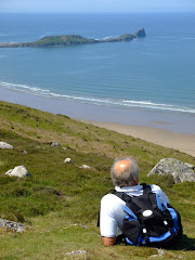
In the last twelve months we have climbed to the highest points of Rhossili Down with the magnificent view of Worms Head and Mynydd Llangatwg just to proudly stand next to the iconic Trig. Pillar.
Like an iceberg, there is more of a Trig. Pillar below the surface than above it - all hikers salute the Trig. Pillar in the existence of it's seventy-fifth year.









No comments:
Post a Comment