Pen-Y-Fan from Cribyn
Learn to fall in love with the mountain not just the summit

Thursday, June 30, 2011

Nash Point


As a gesture of support for the industrial action taken by the teachers union against the proposed Government changes to their pensions, Wandering and Lord Twynyrodyn decided to spend the day in a rather less confrontational environment. The initial destination was the beach car park at Llantwit Major on the South Glamorgan coast. Arriving at 10:45 after a pleasant journey through the country lanes when the topic of conversation was inevitably the policies of the coalition, they joined the Glamorgan Heritage coastal path just to the rear of the beach front cafe.


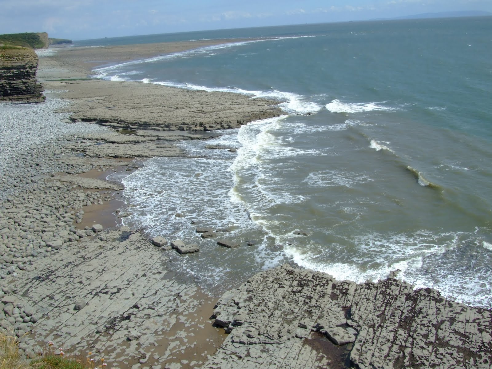
They immediately gained some height climbing to the cliff top for an exhilarating walk along the layers of limestone rock faces which are separated by softer layers of shale (mudstone). The shale often wears away quicker than the limestone leaving it unsupported, causing it to collapse and fall to the beach.

The rocks forming the cliffs were created during a period of the Earth's history called the Liassic, which was part of the early Jurassic times. This was about 180 million years ago.


The first sighting of St Donat's Castle, over a mile in the distance, is from the coastal path itself. A medieval castle built in the late 12th century, it directly overlook's the Bristol Channel. Since 1962 the castle has housed the international Sixth form of Atlantic College.


After seeing photographs of the castle in Country Life magazine, it was purchased and renovated by American newspaper magnate William Randolph Hearst in 1925. Hearst, who at the time was having an affair with the actress Marion Davies, spent a fortune upgrading the castle, installing electricity not only to his residence but also to the surrounding area. Hearst was renowned for holding lavish parties at St Donat's - guests included Charlie Chaplin, Douglas Fairbanks, and a young John F. Kennedy. Upon visiting St Donat's, George Bernard Shaw was quoted as saying: "This is what God would have built if he had had the money."

After Hearst's death in 1951 the castle was eventually purchased in 1962 by Monsieur Antonin Besse II (1927 - ) and given to the Governing Body of Atlantic College.

The College was founded by the German educationalist Kurt Hahn — who also set up Gordonstoun School in Scotland and the Salem School in Germany — as a practical response to the search for new and peaceful solutions in a world riven by political, racial and economic divisions (not a great deal has changed in the last fifty years!)

When Atlantic College opened it was hailed by The Times as "the most exciting experiment in education since the Second World War."


After passing the sea-front promenade to the rear of the college (the students were practicising rolling canoe's in the open air swimming pool in the grounds of the college!), the walk climbs into extremely pleasant woodland until you emerge once again onto the coastal path.


Soon on the horizon in the distance we saw our first glimpse of Nash Point Lighthouse, over an enormous field of wheat that ran almost to the cliff edge.

Nash Point itself is a promontory headland on the Monknash Coast. The Lighthouse was designed by James Walker, the chief engineer for Trinity House. Established in 1832, the lighthouse was electrified in 1968. Nash Point Lighthouse became the last manned lighthouse in Wales, and was only automated in 1998.


Trinity House provide public tours of the lighthouse on a Wednesday, Saturday or Sunday from July to September. The massive foghorn is blown on the first Saturday of every month and third Sunday.


At this point we had to leave the coastal path and head in-land across a series of open access fields before arriving at Marcross, where we spent an hour in a delightful village pub called the Horseshoe Inn - the pint of Cwrw Braf and bar-food is highly recommended.


The road heads east opposite the Horseshoe Inn, passing the Old Schoolhouse and Marcross Court, before taking a right turn down a 'C' road. This led to a section of the Millenium Trail, in another area of woodland that joined and passed through part of the grounds of Atlantic College itself.

Leaving the College the walk passes through King George Fields before rejoining the coastal path for the short return leg to Llantwit Major beach. We decided to leave the coastal path for the last half mile and walk from Treslian Bay to the car park over the slabs of rock created by the build up of millions of shells of tiny sea creatures, together with mud brought into the sea by ancient rivers. Eventually hundreds of metres of this sediment became compacted to form limestone. We enjoyed an ice-cream on the beach prior to the journey home.


The walk was 9 miles and took approximately 4 hours (including an hour spent obtaining refreshments in the Horseshoe Inn!)

Photographs taken on this walk can be viewed here. Select 'slide-show' for automated viewing.

Sunday, June 26, 2011

Penmoelallt Circular


The weather has not been too good since our visit to Skomer so Steve made the most of the warm sunshine to enjoy another local bimble around Penmoelallt.


During the walk he stumbled across these wood carvings along the trail that have been provided by the Merthyr Naturalists Society.


Saturday, June 25, 2011

Glastonbury

The summer solstice, Wimbledon and that music festival held every now and then at Worthy Farm, Pilton all seem to attract the worse of the British weather!

Still if there wasn't any mud it wouldn't be quite the same.

Elbow (who celebrate twenty years playing together) and Coldplay (who return to play the festival for the third time) performances from the Pyramid Stage.

Nb. Well, it looks as though the BBC have gone all bolshi and claimed copyright on all of the Glastonbury coverage. Disappointing because I pay my license fee which allows the BBc to cover the event and I should be able to see the performances on any medium.


Wednesday, June 15, 2011

Trig Pillar's - 75 Not Out


From the Malvern Hills on the Hereford/Worcestershire border to Skomer Island on the western tip of Pembrokeshire, the tall concrete finger pillar which stand at the highest point of any specific hill is instantly recognisable by all hiker's. The 75th anniversary since they were first introduced at the beginning of the re-triangulation of Great Britain was marked in April 2011.

On a clear, crisp spring morning in 1936, a group of men gathered around a strange, pale obelisk in the middle of an unremarkable field in Cold Ashby, Northamptonshire. Those men were there to begin the greatest undertaking Ordnance Survey had attempted since the early 19th century.


At the time Trig. Pillars were part of a state-of-the-art network built to literally re-map Britain. The re-triangulation was to prove an enormous task and lasted 26 years until 1962 (with a break for World War II).


Whether it is on top of Hay Bluff or Fan Nedd in Forest Fawr they all stand in the same proud, upright design and of the original 6,500 Trig. Pillars around 5,500 are still standing.


But time and technologies have moved on enormously to the point where the traditional Trig. Pillar is now virtually obsolete in its original intention. However, they still act as a beacon for weary ramblers but no longer do they help shape our maps.


The modern equivalent of the Trig. Pillar and re-triangulation is the network of 110 Global Navigation Satellite System (GNSS) receivers.


In the last twelve months we have climbed to the highest points of Rhossili Down with the magnificent view of Worms Head and Mynydd Llangatwg just to proudly stand next to the iconic Trig. Pillar.

Like an iceberg, there is more of a Trig. Pillar below the surface than above it - all hikers salute the Trig. Pillar in the existence of it's seventy-fifth year.

Friday, June 10, 2011

Penarth Pier


An early Inter-City connection provided Wandering with an opportunity to visit the Victorian town of Penarth, just a few miles east of Cardiff.


The sea-front is dominated by the Victorian Pier that was built in 1894. Across the Bristol Channel between the Somerset coast lie the islands of Flat Holm and Steep Holm.


A number of people were waiting on the pier to catch the paddle-ship Waverley that sails to Ilfracombe, Lundy Island and Minehead.


In 1947 the 7,130 ton steamship the SS Port Royal Park, under the flag of the Tavistock Shipping Company collided with the pier causing severe damage that was not repaired for several years


The Esplanade Hotel, one of the grandest on the seafront was being demolished.

Wednesday, June 8, 2011

Napes Needle

The Napes are a cliff face to the south of Great Gable. W. P. Haskett-Smith's ascent of the remarkable detached pinnacle of Napes Needle in June 1886 is thought by many to mark the origins in England of rock climbing as a sport in its own right.

Sponsors Berghaus produced this atmospheric video of British climber, Leo Houlding, on Napes Needle.

Monday, June 6, 2011

Springwatch on Skomer Island


After visiting Skomer Island just a few short weeks ago, it will be an absolute pleasure to watch the Springwatch crew filming from this spectacular nature haven all this week.

Even if you miss the opportunity to watch the strange flight of the puffins or listen to the noise created by the manx shearwaters you can always catch up at a more convenient time through BBC iplayer.

For more information see the Springwatch website

Friday, June 3, 2011

Waterfall Country


The prime reason for the Duke venturing along the Nedd Fechan was to exercise his daughter's labrador in an attempt to help it lose some weight!


The section between Pont Melin-fach and the confluence of the river with the Afon Pyrddin is perhaps the most dramatic as the river plunges over several falls, of which Sgwd Ddwli and Sgwd Pedol are the most acclaimed. Each of the falls is associated with faults bringing harder sandstone beds into contact with the more readily eroded mudstones.


Molly, the labrador enjoying her dip in the cold water and playing a game to tease the Duke.


The Hepste, Mellte and Nedd Fechan cascade over layers of millstone grit to create the spectacular waterfalls.

The Nedd Fechan or 'Little Neath' rises on the eastern slopes of Fan Gyhirych in Fforest Fawr and flows south for 12km to join with the Afon Mellte at Pontneddfechan, their combined waters then continue as the River Neath

Wednesday, June 1, 2011

Springwatch


A new series of Springwatch has started on BBC 2. This year the venue has changed to the stunning RSPB reserve Ynys-hir in Mid Wales.

Fledgling woodpeckers, osytercatchers, herons, buzzards, barn owls and redstarts have already been seen on the live webcams... and there's more to come over the next three weeks, including a visit to Skomer Island.

The programmes new home is based in the remote, breathtakingly beautiful and biologically fascinating RSPB nature reserve in Ceredigion, Mid Wales.

The Springwatch website is here and if you miss any episodes you can always catch up on BBC iplayer