
After pulling into the car park Wandering asked Lord Twynyrodyn whether he had checked the tide times? Oh no, not that old chestnut again?
"B*ll@x, why didn't you suggest that before we left!" came the response!
 As you can guess this was a last minute choice. Anyway after paying to park all day (£5), it was a stroll across the almost deserted beach (apart from the lifeguards on a training exercise) before joining the Coastal Path and yes the tide was on the way out!
The steep steps in the far corner of the bay below the apartment block, took us onto the coastal path itself towards Brandy Cove and Pwll Du Bay.

As the name suggests - Brandy Bay was named after the smuggling which took place there. The small, quiet bay was used to unload illegal tobacco and alcohol during the eighteenth century.


We followed the cliff top path until Pwll Du Bay, which consisted of millions of pebbles that formed part of the large shingle bank. Pwll Du or "Black Pool" is one of the most inaccessible bays on Gower so remains unknown to the majority of visitors. The pool is caused by the shingle bank blocking the river flowing into Pwll Du bay.

Previously there were five public houses in Pwll Du Bay, but now only two actually remain as private houses - Ship Cottage (Ship Inn) and Beaufort House (Beaufort Arms). We spoke to a couple who owned one of the houses about the route ahead.
We continue uphill through the woodland, towards Pwll Du Head rejoining the coastal path. During the smuggling activities the 300 foot high headland provided a very convenient vantage point to keep an eye out for customs officers.
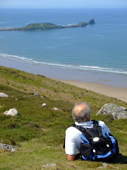
 We were able to eat lunch with a magnificent view above Pennard Cliffs looking towards Three Cliffs and Oxwich Bay.
 Leaving the coastal path we entered Bishopton woods eventually reaching the path next to the stream on the valley floor.
Keeping the stream to our right, we continued through the dense woodland looking for the point where the stream re-surfaced from under ground.

We were able to located both Long Ash Mine, an old silver lead mine and a small cavern called Guzzle Hole, where the sound of the the river running underground is surprising loud!

After leaving the Guzzle Hole the route on the map indicated that the walk continued north along the dry river-bed. Well we passed two disused quarries on the way to Church Lane and then realised that the directions were naff! It was only when we refreshed ourselves with a pint in the Joiners Arms in Bishopstown that we established that we had gone too far on the dry river-bed!
 After a short walk through the village we stood on the corner of Pwll Du Lane looking for Brandy Cove Road. Wandering pointed out the street sign to Lord Twynyrodyn - it was difficult to curtail the laughter when we realised that we were already standing in Brandy Cove Road.
The bridle path led back to Brandy Cove and from there we re-traced your steps along the cliff-top path back to Caswell Bay and a cup of tea in the beach front cafe.
The walk was nine miles and took us four hours, with stops for lunch and alcoholic refreshments.















No comments:
Post a Comment