
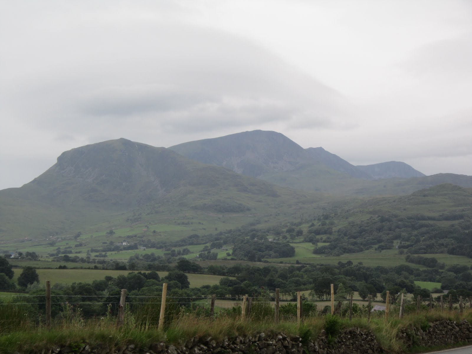
Following previous clips of intrepid walkers on Crib Goch,a knife edge arête in Snowdonia, this particular video version is not for the feint hearted!
The literal translation of the name of the arête means 'red comb', presumably referring to the serrated ridge and the colour of some of the rocks.
The highest point on the arête is 923 metres (3,028 ft) above sea level. All routes which tackle Crib Goch are considered mountaineering routes in winter or scrambles in summer—meaning that they must cross "graded territory".
The classic traverse of Crib Goch from East to West leads up from the Pyg track to a "bad step" where there points of contact, i.e. hands and feet, are both briefly needed. It is followed by ascent to the arête, before tackling three rock-pinnacles to a grassy col at Bwlch Coch.
When you have made the decision to start the traverse it is extremely difficult to turn back!
WARNING: This video should not be viewed if you suffer from vertigo!!!
Friday, November 30, 2012
Sunday, November 18, 2012
Personalised Map Cover

A fantastic new development, launched recently by Ordinace Survey, now allows customers to add their favourite image to the front cover of their personalised map. You can now put yourself on the cover of your very own map!
This latest development is bound to be popular and has been launched just in time for Christmas!
Last ordering date (for postal delivery) is 19 December, so you’ve got plenty of time to get your order in!
Based on the popular OS Explorer Map and OS Landranger Maps, custom made maps give the customer the chance to create a bespoke map centred on any chosen location. Since its launch in Spring 2012, thousands of personalised custom made maps have been created centred on home addresses, favourite walks, holiday destinations and other chosen locations across Great Britain.
This latest advance gives customers the option to create an extremely personal map by uploading any image they wish to feature on the map cover. For example they could upload a picture of their house, school photograph, favourite orange tree or even, if it is their dog walking route, a picture of their dog.
Tuesday, November 6, 2012
Winter Training
The shorter winter days dis-courage a healthy exercise regime although the incentive to maintain even a moderate level of fitness provides the essential target to aim for prior to the clocks going forward again in the Spring.
Even spinning the wheels only a few days a week during the winter months will help with the cardiovascular exercise.
Christophe Le Mevel of Garmin show how the professional cyclist trains during the sub-zero temperatures in the high altitude.
Even spinning the wheels only a few days a week during the winter months will help with the cardiovascular exercise.
Christophe Le Mevel of Garmin show how the professional cyclist trains during the sub-zero temperatures in the high altitude.
Saturday, October 27, 2012
Pennard, Gower

The really strong winds that were blowing across Swansea Bay as we passed St. Helens had virtually disappeared by the time that we reached the sea front car park at Pennard.
With clear blue skies and warmish sunshine, the air temperature was approximately 9 degrees as we walked along the headland on the outward loop eastwards from Southgale. At the furthest point we were able to see Caswell Bay in the distance. As we returned to Southgale we were surprised to establish that this particualr section was actually linked to the Pwll Du walk which we made in September 2011.

We returned in a westerly direction along the 'C' road towards Pennard. A few quiet moments were taken sitting on the bench at the car park looking out to the flat calm sea.
Forsaking the main footpath used by the majority of walkers Lord Twynyrodyn and Wandering decided to scramble down the 100 foot limestone cliff face to the beach below, without knowing at the time whether it would even be possible to make it safely to the bottom.

After posing for the obligatory photo at a rock promontory it was firstly a grass bank and then a slide down loose screed before tackling the final rocky outcrop. Circumnavigating a wide crevice in the rocks, the two 'veterans' managed to keep their feet long enough to make it to the safety of the sandy beach.

The bay takes its name from the three sea cliffs that jut out into the bay. The beach routinely qualifies for Blue Flag status. Inland about 500 yards from the main beach on high ground above Pennard Pill is Pennard Castle, which was built in the early 12th century.

In June 2006 the BBC Holidays at Home programme declared Three Cliffs Bay to be Britain's best beach. In a recent programme broadcast in the UK the view over Three Cliffs Bay was nominated for "Britain's Best View".

To leave the beach the duo needed to walk though the natural arch created in the rock, because Pennard Pill, the river that bisects the beach, was too deep to cross. After leaving the beach and crossing a wooden bridge we had to climb a steep, energy sapping sand dune to reach the ruins of Pennard Castle.

We crossed a section of the links golf course and passed the clubhouse before making our return to the car park, but only after his Lordship had enjoyed a bowl of hearty Pumpkin Soup (to celebrate All Hallows Eve) in the cafe before departing after our excellent adventure on the Gower Peninsular.
Photographs taken on this walk can be viewed here. Select 'slide-show' for automated viewing.
Sunday, September 16, 2012
Abergavenny Food Festival
Regarded my many highly respected gastro's as the 'Glastonbury of food festivals' the highlight of this year's visit for Wandering were the Churros dipped in chocolate sauce by Churros con Chocolate.
Christmas Food Festival takes place on Sunday 9th December.
Festival website
Christmas Food Festival takes place on Sunday 9th December.
Festival website
Friday, September 14, 2012
Stage 6 - Tour of Britain 2012


It was always the intention of Wandering to be a spectator on this stage of the Tour of Britain but Lord Twynyrodyn expressed a curious interest when it was mentioned in a conversation between them, so it was two Strollers that made the short journey to the Storey Arms at mid-morning.

The start of this stage was from the National Trust's Powis Castle completing a loop of Welshpool before a fast descent of the Honddu valley. Soon after leaving Brecon the A470 gradually begins the climb in the shadow of Pen-Y-Fan, as the steepness of the gradient increases after Libanus, which starts the seven-kilometre SKODA King of the Mountains climb up to Storey Arms.
There were big crowds lining the route north of Storey Arms as we took our vantage point. Because of significant head-winds the peloton was behind schedule as they thundered past heading towards the open moorland that eventually descends to Penderyn and Hirwaun.

A brief climb to Ystrad Mynach through Nelson and Parc Penalta, towards Llanbradach to the edge of Caerphilly. The route passed Caerphilly Castle taking the one-way system the wrong way in order to maximise the approach to the climb, which proved to be one of the iconic moments of this years Tour of Britain.
The stage was eventually won by Leopold Koenig, of the Team NetApp with Jonathan Tiernan-Locke, of Endura Racing taking second place on the stage and overall GC winner.
Brief video footage taken by Wandering as the peloton passed our vantage point on the climb to the Storey Arms!!
Wednesday, September 12, 2012
Mercy
A thought provoking video from the Dave Matthews Band.
"Mercy" embraces the song's themes of unity and harmony in a new collaborative video, made with the help of a few thousand fans. According to the band, 14,334 people provided original photos and videos for the inspirational clip.
Matthews recently told 'Billboard' that he hopes this release "inspires [people] to find the things that they love, inspires them to feel good, to feel love, or ambition, or feel powerful. Whatever they need."
"Mercy" is realesed from the Dave Matthews Band's latest album, Away From the World.
Thursday, September 6, 2012
Garth Mountain

This was a walk that was partially abandoned earlier this year in low cloud, so with the recent spell of good weather a 'second attempt' was made to reach the summit trig point.
Another reason for completing the walk was football related. During 2010/11, the Martyrs spent a season in exile away from our spiritual home of Penydarren Park, during the games in the Western league I often used to gaze up at Garth Mountain and wonder what the Rhiw Dda'r ground looked like from the bluff, 1,000 feet above the extremely busy A470.

Well I was about to find out.
The early stage of the walk was exactly the same as the original, starting from the Lewis Arms car park. However, on this occasion I climbed the steep path that eventually led to the bluff, that is so prominently visible from the A470 as you approach the outskirts of Cardiff.

And there it was the ground were the Martyrs spent a year in exile climbing their way back through the non-league pyramid.

The all-round views are really spectacular. With Cardiff Bay to the South and Castell Coch just a few miles away, to Llantrisant in the west and Caerphilly Mountain in the north-east. After gazing at the two main communities situated directly beneath the mountain - Taff's Well and Gwaelodygarth, it was onwards to the trig point.

The circular route was completed when you leave the mountain to return through Pentyrch and back to the Lewis Arms.

The movie staring Hugh Grant, 'the Englishman Who Went Up a Hill But Came Down a Mountain', is based on a story about the village of Taff's Well and the neighbouring Garth Hill.
Set in 1917 (with World War I as a backdrop), the film is based on two English cartographers. They arrive to measure the local "mountain" – only to cause outrage when they conclude that it is only a hill because it is slightly short of the required 1000 feet in height. The villagers, aided and abetted by the wily Morgan the Goat and the Reverend Mr Jones (who after initially opposing the scheme, grasps its symbolism in restoring the community's war-damaged self-esteem), conspire to delay the cartographers' departure while they build an earth cairn on top of the hill to make it high enough to be considered a mountain.
Saturday, August 4, 2012
St. Davids

After a welcome overnight rest in the Golden Lion, Newport, a non-walking day consisted of a visit to St Davids Cathedral. The walking clothes were still drying out after yesterday's drenching!
Set a few miles inland from a spectacular Pembrokeshire peninsula jutting out into the Atlantic, upon the site of an earlier sixth-century monastery built by St David, the Patron Saint of Wales, St Davids Cathedral has been a site of pilgrimage and worship for more than 800 years.

The monastic community was originally founded by Saint David, Abbot of Menevia, who died in 589. Between 645 and 1097, the community was attacked many times by raiders, including the Vikings, however, it was of such note as both a religious and intellectual centre that King Alfred summoned help from the monastic community at St. David's in rebuilding the intellectual life of the Kingdom of Wessex.
In 1081, William the Conqueror visited St. David's to pray, and thus recognised it as a holy and respected place.

Work on the present cathedral began sometime between 1180 and 1182 and is the culmination of centuries of rebuilding and expansion. Constructed in the Transitional Norman style using fine-grained, purple Cambrian sandstone, it has survived both the collapse of its tower and an earthquake in the 13th century, although today the floor slopes noticeably, the arcades veer from the vertical, and the east and west ends of the building differ in height by about four metres!

The restored Shrine of St David was unveiled and re-dedicated by The Right Reverend Wyn Evans, Bishop of St Davids, at a Choral Eucharist on St David's Day 2012. Sarah Crisp painted and gilded the five icons which have been installed to sit within the exisiting niches of the restored shrine. The icons, made in egg tempera on gesso, depict St David and other saints associated with the cathedral and the local area. The three icons at the front of shrine depict from left to right: St Patrick, St David and St Andrew. The icons are painted on lime wood panels and combine the styles of classic Byzantine with early Italian works. Traditional paint and techniques were used throughout.
The Cathedral has also been used as a location for a BBC production called "The Hollow Crown" as part of the castle of Richard II.
The title of "city" was re-instated to St. David's, and formally conferred by Her Majesty Queen Elizabeth II on 1 June 1995.

The weather had been glorious all day in St. Davids and reluctantly it was decided to return to Newport Sands where ice-creams were consumed before it started to rain!!
Friday, August 3, 2012
Poppit Sands to Newport


Boarding the Poppit Rocket outside the Castle Hotel in Newport at 10:30am the weather was blustery but sunny. The journey to the start of the walk took over half an hour along the narrow Pembrokeshire country lanes via Moylegrove.
After departing the 'Rocket' in the large car park at Poppit Sands on the mouth of the River Teifi, the costal path starts to climb almost immediately following a minor road past the Youth Hostel to Allt-Y-Goed Farm, where it becomes a footpath.

This takes you to Cemaes Head which is now a nature reserve owned by the Wildlife Trust, where guillemots, cormorants, fulmars and razorbills nest in the cliffs in Spring and early Summer, but not today!

The geology of this section of the coastline is spectacular. The cliffs at Pwll Granant in places are 600 feet high and consist of layers of sandstone and mudstone.
Arriving at Ceibwr Bay after a few hours walk the weather had remained kind. The steep valley down which the Nant Ceibwr flows was deepened by glacial meltwater in the Ice Age. Lunch was taken overlooking a group of school children coasteering along the rocky outcrops in the bay below.


Less than a mile further along the coastal path is the Witches Cauldron (Pwll-Y-Wrach) which is a natrually formed blow-hole caused by the collapse of a cave roof.

Soon after this point the weather deteriorated and it started to rain and the conditions were made difficult by the prevailing head-wind. This particular section of the coastal path is remote and extremely challenging, rising and falling quite dramatically in places. After the downhill trundle you know that a trudge upwards is always inevitable!

Before turning the headland a shoal of porpoises were clearly visible in the sea below.

After five hours the welcome sight of Newport Sands and the Nevern Estuary finally came into view, although there was still a few miles to walk to reach the Golf Club.
Over half of the 15 mile walk had been completed in driving rain and strong head-winds!
Photographs taken on this walk can be viewed here. Select 'slide-show' for automated viewing.
Wednesday, August 1, 2012
Wiggins wins Olympic Time Trial

Bradley Wiggins wrote his name into Olympic and cycling history at Hampton Court with a superb gold medal in the men's time trial. He was now won more Olympic medals than any other Briton: seven in total, including four gold. Team Sky rider Chris Froome won a bronze medal.
Wiggins, who also won the Tour de France less than two weeks ago, destroyed the field with a sensational ride to cover the 44km course in 50min 39.54 seconds, an impressive 42 seconds ahead of the the world time trial champion Tony Martin from Germany, who took the silver medal in 51:21.54.
There was further joy for Great Britain when Froome, who was the main support rider to Wiggins in the Tour de France, fought his way round the course to take the bronze medal, at an average speed of just over 30mph to finish in 51:47.87.
Wiggins's also equalled the achievement of his boyhood hero Miguel Indurain in winning the Tour de France and the Olympic time trial.
He produced a beautifully balanced effort over a course which was packed all the way by supporters waving union flags, a once in a lifetime experience for a British rider. Police estimate that there were in excess of 300,000 lining the roads.
"I cannot put it into words, I wouldn't do it justice," Wiggns said. "It’s really incredible to win an Olympic Gold in your home city. When you win in the velodrome there are three or four thousand people cheering. Here, around the streets of London, the noise is just amazing. I don't think anything will top that. It's just been phenomenal."
Tuesday, July 24, 2012
Summer Weather

One of the reasons for the lack of trip reports has been the appalling weather. It was exactly two years ago that we had the driest Spring for 80 years, see previous post on the local reservoirs.
The last of the hosepipe bans in the southeastern corner of England were lifted a couple of weeks ago, and not before time. Normally the water year begins in October, when the reservoirs and water-bearing rocks beneath our feet begin to fill up again after the summer. Since March 2012 we have had an excess of 220mm of rainfall and the reservoirs are full.
It has all been the fault of the mid-latitude jet stream, that powerful conveyor belt of winds in the upper atmosphere.
The jet stream is located in the zone of biggest temperature contrast. These huge temperature contrasts (between the Artic and Equator) provide the energy which drives this narrow stream of powerful winds. The jet stream also controls the behaviour of the depressions that we see on the TV weather charts, and these depressions routinely bring widespread rain, and often strong winds.
Throughout the 1990s and the early-2000s the jet stream blew powerfully from the west, and the distribution of weather across the UK was relatively normal, with just a few exceptional droughts and wet periods. Since 2003, however, the flow has been sluggish and meandering, and as a result we have experienced long periods when the weather has appeared to get stuck in a rut. So we had heat-wave summers in 2003 and 2006, appalling floods in 2007 and now in 2012, and an extended drought in 2010 and 2011.
It seems that the six-week long period of thick cloud and heavy rain may be drawing to a close. The weather should take a turn towards something rather drier, sunnier and warmer.
The last time the Olympics came to London, in 1948, we had a dreadful summer, apart from two weeks at the end of July. King George VI opened the Olympic Games on the hottest day of the year with 35C (95F) approached in London and the Home Counties. But sadly that year the rains returned in August.
Sunday, July 22, 2012
Champs-Élysées, Paris

Wiggins won the General Classification with an overall gap of 3 minutes 21 seconds over his most dangerous rival, Sky teammate Christopher Froome. Vincenzo Nibali of Liquigas-Cannondale took the other podium place, finishing third overall 6 minutes 19 seconds behind Wiggins.
The British rider, who had spent the entire race in either the Yellow Jersey or second place overall, emphatically demonstrated his intentions with two time trial victories, winning against the clock on stages 9 and 19 to virtually guarantee the title. The only rider who was able to sustain any challenge was his teammate and lieutenant, Froome.
Friday, July 13, 2012
Cadair Idris
It was an extremely early start for the intrepid duo as the headed north on the A470 towards Gwynedd and the 'Chair of Idris' protruding into the low cloud at 893 mtrs.

The chosen route, the Pony Path, begins in the north from either Dolgellau or the Mawddach estuary, is the easiest but the longest of the main trails. Its length from the mountain's base is 5 kilometres (3.1 mi) with a 600 metres (2,000 ft) climb.

The Idris in question is usually taken to be a giant from Welsh mythology who was said to have used the mountain as an enormous armchair to gaze at the stars. Alternatively, it may refer to Idris ap Gwyddno (or Gweiddno), a 7th-century Meirionnydd prince who won a battle against the Irish on the mountain.

Lord Twynyrodyn experienced periodic breathing difficulties on the upward route that seemed to evaporate when chatting to some pretty Swiss girls. The cloud cover also cleared as the summit was conquered.

There was a tricky little scramble for the duo over the loose scree to reach the summit.

Refreshments were taken at a local hostilry at the base of the mountain before the departure for home.
Friday, June 29, 2012
Crash Into Me
From the 'Crash' album released in 1996, the single reached #2 in the US album charts before the band recorded 6 consecutive #1 albums in the American LP charts over the next 16 years.
The song has also been covered by various artists including Stevie Nicks formerly of Fleetwood Mac, who performed it on her 2008 Soundstage episode. Her version was later released as a single.
The video was recorded live at Continental Airlines Arena in East Rutherford, New Jersey
The song has also been covered by various artists including Stevie Nicks formerly of Fleetwood Mac, who performed it on her 2008 Soundstage episode. Her version was later released as a single.
The video was recorded live at Continental Airlines Arena in East Rutherford, New Jersey
Sunday, May 27, 2012
Haga District

The morning of our final day in the second largest city in Sweden was spent wandering around the Haga district and a general wide sweep of the main harbour area.
Fortunately, most of the stores were closed for the Sabbath so very little money was actually spent!
Haga is renowned for its 19th century-atmosphere and cafés. Originally a working class suburb of the city with a rather bad reputation, it was gradually transformed into a popular area for both tourists and local residents.

The district was first established in the mid-17th century by Queen Kristina, making it Göteborg's first suburb. It was not until the 1840's that new industries were established in Göteborg, which led to an influx of workers into Haga, creating the first worker's district in the area. This led to a housing shortage during the 1870s and by the 1920s, after extensive expansion of the district, the population of the area began to decline.
A redevelopment plan drawn up in 1962 for Göteborg, which included the demolition of buildings in the district, in 1970 led to the founding of the Haga Group, with the aim to preserve the original architecture of the area. Between 1973 and 1977, demolition work decreased due to the pressure of the locals. This also moved the authorities to help restore some of the buildings which were already in disrepair.

Feskekôrka is a fishmarket by the Rosen Lundskanalen in the heart of Gothenburg. Feskekôrkan was opened on 1 November 1874 and the name is derived because it is compared to a church. In the 18th century, fishing was the most important industry for the city. In the past the fish market was a significant meeting point for residents of the city. However, in 1731 the Swedish East India Company was founded, and the city flourished due to its foreign trade with highly profitable commercial expeditions to Asian countries.

The harbour area developed into Sweden's main location for trade towards the west, and with Swedish emigration to North America increasing, Gothenburg became Sweden's main point of departure.

A lovely city with excellent facilities but rather flat!
Saturday, May 26, 2012
Aspero Island

After a typical Swedish breakfast we used the local transport service in the city which is absolutely superb, with trams that are both punctual and extremely clean, to rendezvous with Wandering Junior.

The weather was wonderful and we were able to use a ‘rover’ travel card to catch the tram from the city centre to the coast before boarding a ferry at Saltholmen on the short but pleasant 15-minute journey to Aspero Island (402 inhabitants in 2010).

This is part of the Southern Gothenburg Archipelago, which has 5,000 permanent and another 6,000 summer residents.

It was fascinating to learn about the traditional Swedish life-style, as families retreat to the coast for the long Summer holidays to the wooden clapper-board holiday homes. The Swedish are very supportive of a good work/life balance.

The only mode of transport allowed on the island was bicycle or a motorised type of golf buggy!
We spent an hour or so walking from the jetty to the main ‘street’ that consisted of the only general store on the archipelago! Enjoying an ice-cream beside the glistening crystal clear waters. Catching the ferry back to the mainland from the second jetty on the island later in the afternoon.

Subscribe to:
Posts (Atom)


