
Some basic navigation skills along the narrow country lanes confirmed our arrival at the starting point at the conveniently remote parking area at Blaen Llia forestry. Crossing the bridge over the Avon Llia we started the relatively gentle climb of Cefn Perfedd along this particular section of the Beacons Way. Firm short-cropped grass and patches of bracken created excellent hill-walking conditions underfoot.

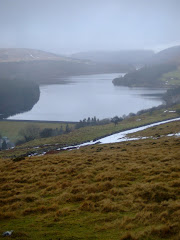
Less than forty minutes later we had reached the cairn at 600 metres just below the summit of Fan Llia (2,071 feet). With superb views including Ystradfellte Reservoir and Fan Fawr to our east we continued to Fan Dringarth before turning westward to start the descent to the neolithic standing stone at Maen Llia. With no pre-defined path the going wasn't easy over the tussocks of grass.

Both Steve and I agreed that the weather conditions were perfect for walking. With wispy strands of cirrus clouds high above us at an altitude of 20,000 feet confirming the fine weather. They never produce rain as the clouds form in such a cold part of the atmosphere that they contain only ice crystals. Seeing the cirrus clouds provided us with reassurance that we would not need to use the waterproofs today.

The proud standing stone at Maen Llia is perfectly aligned on a magnetic north/south axis between Ystradfellte and Defynnog. Dating from the Bronze age, it is likely that a quarter to a third of the stone is located below ground level, helping it with-stand thousands of years of wild Welsh weather. The landmark is clearly visibile from some distance and this suggests that it could possibly be a territorial marker or was used to guide travellers down an ancient trackway. Some faint Latin and Ogam inscriptions were visible on the stone's surface until recently.

There is a common legend attached to many standing stones, when usually at mid-summer, the stone 'gets up and goes for a walk' down to the local stream or lake. At sunset on Mid-Summers Day, the shadow from Maen Llia is at its longest. It stretches for over 300 metres and goes through the stream of the Afon Llia. The shadow, because of the shape of the stone and the angle of the setting sun, looks like a tongue, and this could be interpreted as 'going down to the stream for a drink'. if you combine this with the alternative translation for 'Llia', which is to 'lick or to lap', then 'Maen Llia' is literally the licking stone, or the stone that licks (or laps).
Our expertly timed arrival at Maen Llia allowed us the luxury of a well deserved lunch interval before crossing the road that splits the valley to commence the ascent towards Fan Nedd (2,176 feet) via a ladder-stile.
 This particular ascent was much tougher then the relatively gentle climb of Fan Llia although we both found the steepest section near the summit to be the easiest!! The views when we arrived at the 'cone shaped' cairn at the northern end of the ridge were spectacular, with the giant of Fan Brycheiniog (definitely another one to do really soon!) to the west and Penyfan in the east.
We then reached the haven of tranquility at the trig point over-looking the Mellte valley at 663 metres before the easy descent and our return to the parking area. This was thirsty work and a compulsory rest and recuperation stop at the Nant Ddu was essential.

This particular walk was 11km (7 Miles) with a link to the map of the route here.
All of the photographs taken on this walk can be viewed here. Select 'slideshow' for automated viewing.















No comments:
Post a Comment