
Almost 100 miles (161km) of footpaths in the Brecon Beacons have recently experienced major improvement. The extremely popular Beacons Way route across Powys, Carmarthenshire and Monmouthshire has been upgraded thanks to current wardens and volunteers.
The path has been eroded by heavy rainfall, with bridges and walkways near area's of waterfalls also being improved. Funding of £92,000 for the project came from the Countryside Council for Wales and the Welsh Assembly Government.
The improvements were made to three sections of the Beacons Way, which traverses nearly 100 miles across the national park from Skirrid Mountain, near Abergavenny, to Bethlehem in Carmarthenshire.
The first section of repairs started at the foot of Craig y Fan Ddu in the central Beacons. A second section - the path from Llyn y Fan Fawr to Fan Brycheiniog - was also upgraded to minimise erosion and improve the experience for walkers. While a third section of the footpath in Carmarthenshire received a new non-slip walkway, along with way marking and sign posting improvements.
Richard Ball of the national park authority said: "The three footpath sections that we've improved along the Beacons Way are strategically very important and will have a significant impact on the walkers who use this route regularly - particularly the Craig y Fan Ddu section of the Beacons Way walk which stretches from Llangynidr to the Storey Arms. This steep and popular section of the route was identified as being in poor condition and in desperate need of repair by walkers and national park staff who survey the route annually."
Showing posts with label Beacons Way. Show all posts
Showing posts with label Beacons Way. Show all posts
Tuesday, March 8, 2011
Saturday, July 3, 2010
Local Reservoirs

With the driest start to the year since 1929 (January to June 2010 has been the second driest for 100 years) and a distinct lack of precipitation over the last eight weeks (nationally only 68% of average rainfall) water levels on all of the local reservoirs are really low.
Just over 14 weeks ago the reservoirs were gripped in a deep freeze with large area's of the surface frozen solid but one of the driest periods in the last eighty years has seen a remarkable transformation to the visual landscape.
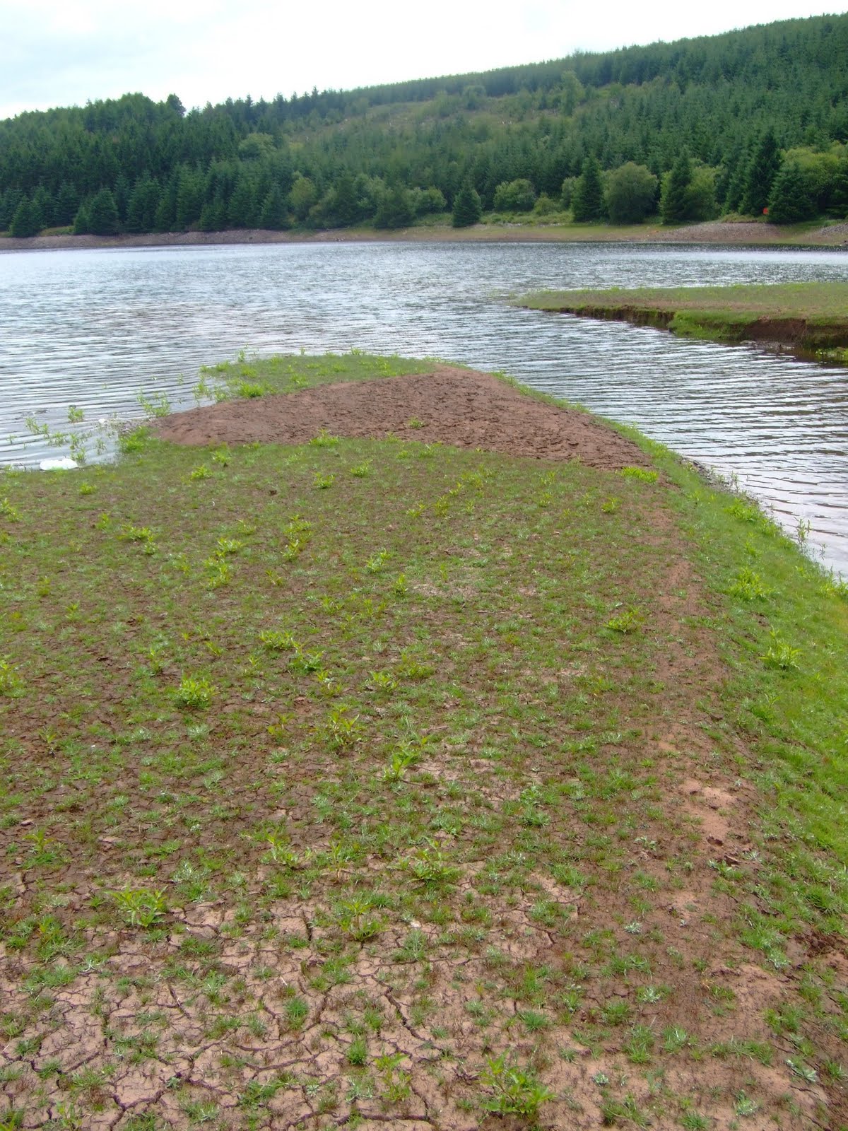
I set off along the Beacons Way in the direction of Llwyn On (also known locally as First Res.) to discover that the water level on the dam had dramatically dropped by approximately 20 feet.

Constructed in 1926 to supply the inhabitants of Cardiff, it has a capacity of 1,260 million gallons. If the current drought continues the remains of Ponty Daf Bridge, which normally remains hidden below the surface, will soon be visible. Welsh Water are satisfied with the current average capacity of 72% and do not anticipate any water restrictions until the Autumn.

The next stop was at Cantref Reservoir (which is known locally as Second Res!!) where the exposed earth banks were starting to crack as they dried out.
These butterfly's were in their natural habitat near the Nant Crew Bridge at the northern end of the Cantref Reservoir.

Probably the worst affected locally was Dolygaer Reservoir, which covers about 40 acres and has an average depth of 18 feet. With such low water levels the Environment Agency Wales has rescued hundreds of fish nationally due to the exceptional drought conditions.

While I was at Dolygaer this Heron was able to wade near the middle of the rapidly diminishing expanse of water in search of it's next meal! it's surprising how nature is able to adapt to the extreme conditions.

All of the photographs taken on this walk can be viewed here. Select 'slideshow' for automated viewing.
Friday, June 11, 2010
Fforest Fawr
Conveniently tucked between the Brecon Beacons and Mynydd Du (Black Mountain), with the Senni valley from the north and Mellte valley from the south merging to split both two thousand feet peaks of Fan LLia and Fan Nedd - which were our initial targets on the opening day of the 2010 World Cup in South Africa. Probably one of the 'forgotten' hill regions of South Wales, they certainly appeared to live up to their reputation today because in this vast open space we appeared to be the only two visitors! The whole western area of Fforest Fawr is part of the privately owned Cnewr Estate, with a section of our chosen route closed annually between 15th April and 10th May for lambing.

Some basic navigation skills along the narrow country lanes confirmed our arrival at the starting point at the conveniently remote parking area at Blaen Llia forestry. Crossing the bridge over the Avon Llia we started the relatively gentle climb of Cefn Perfedd along this particular section of the Beacons Way. Firm short-cropped grass and patches of bracken created excellent hill-walking conditions underfoot.

Less than forty minutes later we had reached the cairn at 600 metres just below the summit of Fan Llia (2,071 feet). With superb views including Ystradfellte Reservoir and Fan Fawr to our east we continued to Fan Dringarth before turning westward to start the descent to the neolithic standing stone at Maen Llia. With no pre-defined path the going wasn't easy over the tussocks of grass.

Both Steve and I agreed that the weather conditions were perfect for walking. With wispy strands of cirrus clouds high above us at an altitude of 20,000 feet confirming the fine weather. They never produce rain as the clouds form in such a cold part of the atmosphere that they contain only ice crystals. Seeing the cirrus clouds provided us with reassurance that we would not need to use the waterproofs today.

The proud standing stone at Maen Llia is perfectly aligned on a magnetic north/south axis between Ystradfellte and Defynnog. Dating from the Bronze age, it is likely that a quarter to a third of the stone is located below ground level, helping it with-stand thousands of years of wild Welsh weather. The landmark is clearly visibile from some distance and this suggests that it could possibly be a territorial marker or was used to guide travellers down an ancient trackway. Some faint Latin and Ogam inscriptions were visible on the stone's surface until recently.

There is a common legend attached to many standing stones, when usually at mid-summer, the stone 'gets up and goes for a walk' down to the local stream or lake. At sunset on Mid-Summers Day, the shadow from Maen Llia is at its longest. It stretches for over 300 metres and goes through the stream of the Afon Llia. The shadow, because of the shape of the stone and the angle of the setting sun, looks like a tongue, and this could be interpreted as 'going down to the stream for a drink'. if you combine this with the alternative translation for 'Llia', which is to 'lick or to lap', then 'Maen Llia' is literally the licking stone, or the stone that licks (or laps).
Our expertly timed arrival at Maen Llia allowed us the luxury of a well deserved lunch interval before crossing the road that splits the valley to commence the ascent towards Fan Nedd (2,176 feet) via a ladder-stile.
 This particular ascent was much tougher then the relatively gentle climb of Fan Llia although we both found the steepest section near the summit to be the easiest!! The views when we arrived at the 'cone shaped' cairn at the northern end of the ridge were spectacular, with the giant of Fan Brycheiniog (definitely another one to do really soon!) to the west and Penyfan in the east.
We then reached the haven of tranquility at the trig point over-looking the Mellte valley at 663 metres before the easy descent and our return to the parking area. This was thirsty work and a compulsory rest and recuperation stop at the Nant Ddu was essential.

This particular walk was 11km (7 Miles) with a link to the map of the route here.
All of the photographs taken on this walk can be viewed here. Select 'slideshow' for automated viewing.
Saturday, May 22, 2010
Ysgyryd Fawr

An imposing landmark situated just to the north-east of Abergavenny that looks down on the A465 as it trundles below. The 360 degree views from the summit are well worth the climb through the woods from the foot of the mountain.
Leaving a small but equally convenient parking area at the side of the B4521 you walk through a hedge-lined track until you come to a gate to join the Beacons Way. The hardest part of the climb comes at the very beginning of the walk as you make your way through dense woodland, that provided a protective shadow from the fierce sun.
There was an abundance of Cabbage White butterflies in the hedgerows, while Wagtails and Meadow Pipits were also evident.

The welcome breeze at the higher altitude was enjoyable when leaving the wooded slopes after the hard uphill slog, to emerge onto the exposed upper elevation of the mountain that on a clear day can be seen from (another Country!!) over 20 miles away as you leave the outskirts of the city of Hereford on the west bound A465.

The walk along the cats back ridge to the trig point at 486 metres was the final climb before the panoramic views included Grosmont, Hereford and the Malvern Hills in the east, the Black Mountains and the Vale of Ewyas to the north, Abergavenny and the Sugar Loaf to the west. Plus dozens of brightly coloured fields full of Rape Seed in all visible directions.
 The mountain has long been referred to as the Holy Mountain. It has a distinct shape formed by a landslip on one side dating from the Ice Age. The evangelical importance of the mountain was marked with a small medieval place of worship, dedicated to St. Michael, and squeezed onto the narrow summit. Years of mountain top weather have taken their toll and only the outline plus two small standing stones that form a doorway now remain.
Skirrid Mountain, as it is commonly known, was a favourite walk of Rudolph Hess, Deputy Fuhrer of the Third Reich, when he was detained in Maindiff Court Military Hospital (located near to Wern Ddu Farm) during the Second World War, after being captured when his plane crash landed on the way to Scotland.

The thermal currents that create an up-draught around the steep sides of Skirrid make this an ideal environment in which to para glide and while near the summit three 'twenty somethings' literally 'threw' themselves off the edge of the ridge as they launched the huge canopies 'whooping and hollering' to ascend gracefully into the clear blue skies, before circling silently to hundreds of feet above the mountain in a spectacular display. It was definitely an 'I was there' moment in time.

Subscribe to:
Posts (Atom)


