Pen-Y-Fan from Cribyn
Learn to fall in love with the mountain not just the summit
Showing posts with label Black Mountains. Show all posts

Friday, April 29, 2011

Black Hill and Hay Bluff


The drive through the deserted village of Longtown at 11.00am could only mean one thing - all of the inhabitants were watching the Royal Wedding - the event that we had decided to avoid. So it was a major surprise when we arrived at the car park to find it was already full!

I don't think that I've ever been asked whether I'm a botanist before but that was the strange question posed by a very academic looking lady with a posh voice as we changed our boots to start the walk.


The Black Hill itself rises just north of Longtown and west of the village of Craswall, near the Wales/England border. It is known locally as the 'Cat's Back' as when viewed from Herefordshire it looks like a crouching cat ready to pounce.


After the initial steep climb we encountered a tremendous 2 kilometre narrow ridge with the Olchon Valley on the western side and Golden Valley to the eastern flank. This was a really stunning stretch of mountain ridgeway.


Unfortunately, it was windy and cold after the really warm weather of the last few weeks.

We soon reached the first trig. point at Black Hill (640 metres) and then headed north west to join Offa's Dyke Path for the two kilometre walk to the trig. point at Hay Bluff (677 metres). Our second Nuttall summit of the day (both on the English side of the border).

Although the visibility was patchy the views down to the car park near the stone circle at the foot of the Bluff were amazing.


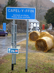
After eating our lunch we started the trek south on Offa's Dyke Path toward Hatterall Ridge. A distinctive path marked on the OS map was rather in-distinctive in reality and we needed to eventually head east at the stone marker at the crossroads to the Olchon Valley and Capel-Y-Ffin. At this point the weather conditions started to improve and the spectacular views began to open up around us.


The decent to the valley floor was an almost vertical drop of nearly 1,000 feet and we commented that we were really pleased that we did not have to climb this at the end of the walk as we passed someone who would shortly be on their way up. We crossed the Olchon Brook and walked through Black Hill Farm en route to the starting point.

After the main cultural spot of the day - a visit to the remains of Longtown Castle, which was built in the 13th Century to keep the maurading Celts out of England - it was a brief stop at the Crown Inn for liquid refreshments before sneaking back over the border into the Principality at Pandy.

The walk was 13.5 kilometres and took four hours thirty minutes including half an hour for lunch and a scheduled tea break.

Photographs taken on this walk can be viewed here. Select 'slide-show' for automated viewing.

Bruce Chatwin used the Black Hill as the setting for his novel 'On the Black Hill'.

Thursday, February 17, 2011

Sugar Loaf


As you approach Abergavenny from Raglan in the east on the straight autobahn-like A40, the distinctive outline of the conical summit of the Sugar Loaf (at 596 metres) dominates the horizon as the southern most peak of the Black Mountains.

It was extremely disappointing to depart from home with blue skies and sunshine to arrive at Abergavenny only twenty minutes later in miserable low cloud. Its normally the other way round!

The approach to the start of the ascent was made via the National Trust car park, from the north-east of the Sugar Loaf about a half mile past Bettws.

Walking during February in either the Brecon Beacons or Black Mountains is often through low cloud and after the initial climb onto the lower plateau, with views of Partishow Hill to the north, the visibility gradually reduced to less than 100 metres.


The only incident of note on the ascent was when I spooked a grouse or pheasant a few feet away in the bracken and heather, that subsequently made me jump at the loud flapping of its frantic wings.

The final climb to the summit is steep and the long narrow ridge, only 20 feet wide, stretches for about 50 or 60 yards from south to north. On a clear day views to the Bristol Channel in the south-east and the Malvern Hills to the north-east can be spectacular, but unfortunately not today.


The only benefit of the poor visibility was the deserted summit where I stayed for 15 minutes.


The Sugar Loaf was donated to the National Trust in 1936 by Margaret Haig Thomas, Viscountess Rhondda, and daughter of David Alfred Thomas who served as a Liberal Member of Parliament for Merthyr Tydfil, from 1888 to 1910.

The walk was 8 kilometres and involved 369 metres (1,100 feet) of ascent, taking 1 hour and forty minutes.

Friday, December 24, 2010

Review Of 2010 - Part Two

Further brief summary of all of the walks that were carried out in the second half of 2010:

Monte Bollettora - 12 July 2010
European trip to the Lombardy region of Northern Italy.
Como to Brunate to Bollettora
Weather: Very Hot

Sarn Helen - 29 July 2010
Roman Road in Fforest Fawr
Mean Madoc standing stone
Weather: Warm

Grwynne Fechan - 5 August 2010
Trek in the Black Mountains
Circular walk to Pen-Y-Gadair Fawr and Waun Rhydd, the highest point in the range.
Weather: Dry and Mild

British Camp - 23 August 2010
Iron age hill fort
Herefordshire Beacon at the start of the Malvern Hills
Weather: Humid, Overcast, Warm and Wet

Twmbarlwm - 16 September 2010
Circular walk from Cwmcarn Visitor Centre to highest point in Gwent.
Stunning views across the Bristol Channel
Weather: Dry, Sunny and Cold

Kilpeck - 16 October 2010
Visit to Norman church in Kilpeck with a de-tour to Grosmont.
Weather: Overcast but Dry

Fan Gyhrych - 28 October 2010
Climb from Cray Reservior to trig. point on Fan Gyhrych.
Weather: Wet and Windy

Taff Trail - starting on 13 November 2010
Three sections of Taff Trail - Cefn Coed to Pontstcill, Rhydycar to Aberfan and Aberfan to Quakers Yard
Weather: Dry and Cold

Hen Rhydd - 10 December 2010
Majestic waterfall country while frozen
Weather: Cold

Saturday, August 14, 2010

South Wales Nuttalls

Like the Munro's in Scotland all hills in Wales that are at least 2,000 feet (610 metres), high with a relative height of at least 15 metres (49.2 feet) are classified as Nuttalls. The definitive list was compiled by John and Anne Nuttall and published in 'The Mountains of England & Wales'.

All of the qualifying hills in the two main regions of South Wales are listed below. In total there are 34 Nuttalls to climb in South Wales.
Check how many you may have climbed?

Black Mountains
Waun Fach (811 mtrs)
Pen y Gadair Fawr (800 mtrs)
Pen Allt-mawr (720 mtrs)
Rhos Dirion (713 mtrs)
Black Mountain 3 (703 mtrs)
Pen Cerrig-calch (701 mtrs)
Twmpa (690 mtrs)
Chwarel y Fan (679mtrs)
Mynydd Llysiau (663 mtrs)
Pen Twyn Mawr (658 mtrs)
Pen Twyn Glas (646 mtrs)
Black Mountain Sth Top (637 mtrs)

Brecon Beacons
Pen y Fan (886 mtrs)
Corn Du (873 mtrs)
Fan Brycheiniog (802 mtrs)
Cribyn (795 mtrs)
Waun Rydd (769 mtrs)
Fan Hir (761 mtrs)
Bwlch y Ddwyallt (754 mtrs)
Bannau Sir Gaer (749 mtrs)
Fan Fawr (734 mtrs)
Fan Gyhirych (725 mtrs)
Fan y Big (719 mtrs)
Waun Lefrith (677 mtrs)
Fan Fraith (668 mtrs)
Fan Nedd (663 mtrs)
Allt Lwyd (654 mtrs)
Garreg Las or Twyn Swnd (635 mtrs)
Fan Llia (632 mtrs)
Fan Frynych (629 mtrs)
Craig Cerrig-gleisiad (629 mtrs)
Y Gyrn (619 mtrs)
Cefn yr Ystrad (617 mtrs)
Garreg Lwyd or Moel Gornach (616 mtrs)

Thursday, August 5, 2010

Grwyne Fechan


Leaving Blaenau Gwent (where the Eisteddfod 2010 is being held – Welsh Learner of the Year on the Maes today), you soon cross over the border into Powys and on the descent from Mynydd Llangynidr the western flank of the Black Mountains is laid out before you in it’s magnificent splendour.

Although the dark storm clouds were gathered over the A470 Heads of the Valley the sun was breaking through less than twenty minutes later as the journey weaved it’s way north of Crickhowell.

The main purpose of the day was to bag a few South Wales Nuttalls (peaks over 2,000 feet…….but more of that in another posting).

The walk started along a narrow country lane bordered by hedges of hazel and holly. After leaving the road just past Pentwyn Farm, I followed the trail that leads from Tir Y Nant into the forest and starts to climb almost immediately gaining height quickly. Before too long I was in open countryside only to disappear into the eerily quiet and darkness of the forest itself for a relatively short period.

Crossing a stile to leave the canopy of trees the trail leads diagonally upwards along a heathery clad hillside with evidence of the early stages of the late Summer wimberry harvest. The sun had started to shine and it was getting warmer as the sheep tracks suddenly started to lead off in all directions! Eventually after about 45 minutes and 750 feet of ascent I joined a wide pathway that runs along the crest of the ridge.

After walking for a mile on the ridge I climbed an insignificant path to a forlorn cairn that marked the heather-clad peak of Pen-twyn Mawr, the first Nuttall of the day at 658 metres. This was also a signal to celebrate the first mini-break of the walk.


The more distinctive summit of Pen-y-Gadair Fawr was a further mile in the distance. The wind had picked up as I approached the second highest peak in the Black Mountains at 800 metres, the windswept summit gained pride of place as the second Nuttall of the day.


Although Waun Fach at 810 metres is actually the highest peak in the Black Mountains (and another Nuttall bagged on the day) it is not very attractive, surrounded by dark peat and approached over coarse boggy grass . However, there were a number of walkers arriving or departing at this central hub.


The journey continues to the west as I departed Waun Fach as the route heads towards Pen Trumau which is a rugged interesting start to the downhill section. Passing through the ‘V’ shaped shoulder at the foot of the col, the original intention was to cut to the left and return to the starting point by the low level Grwyne Fechan route crossing the Hermitage bridge, but I couldn’t resist climbing first Mynydd Llysiau at 663 metres and then Pentwynglas at 646 metres (where I enjoyed another brew) to bag two additional Nuttalls (making 5 in total for the day).

The walk came to a conclusion after the long steady descent down Tal Trwynau with Pen Allt-mawr towering to the west and really MASSIVE awesome views of Grwyne Fechan and Cwn Banw to the east. Passing through some unusual dis-used quarry workings with a particularly distinctive cairn, I finally left the hillside through some open fields and a rickety lane.

This was a really superb days walking in very good conditions.

The total distance covered was 18 kilometres or 11 miles in four and a half hours. A link to the map of the route is here.

All of the photographs taken on this walk can be viewed here. Select 'slideshow' for automated viewing.

Thursday, June 24, 2010

Black (Magic) Mountains Vista

A short bimble to the trig point at Hen Dy-aderyn at 529 mtrs above Llangattock, which we located using the navigational skills of a map and compass!


The glorious vista across the valley included Pen Allt-mawr.


Pen Cerrig-caich above Crickhowell.


The distinctive outline of the Sugar Loaf.


Skirrid Mountain in the far distance to Mike's right shoulder.


And to the west of Gilwern the Blorenge.


A picture is worth a thousand words.

Saturday, May 22, 2010

Ysgyryd Fawr


An imposing landmark situated just to the north-east of Abergavenny that looks down on the A465 as it trundles below. The 360 degree views from the summit are well worth the climb through the woods from the foot of the mountain.

Leaving a small but equally convenient parking area at the side of the B4521 you walk through a hedge-lined track until you come to a gate to join the Beacons Way. The hardest part of the climb comes at the very beginning of the walk as you make your way through dense woodland, that provided a protective shadow from the fierce sun.

There was an abundance of Cabbage White butterflies in the hedgerows, while Wagtails and Meadow Pipits were also evident.


The welcome breeze at the higher altitude was enjoyable when leaving the wooded slopes after the hard uphill slog, to emerge onto the exposed upper elevation of the mountain that on a clear day can be seen from (another Country!!) over 20 miles away as you leave the outskirts of the city of Hereford on the west bound A465.


The walk along the cats back ridge to the trig point at 486 metres was the final climb before the panoramic views included Grosmont, Hereford and the Malvern Hills in the east, the Black Mountains and the Vale of Ewyas to the north, Abergavenny and the Sugar Loaf to the west. Plus dozens of brightly coloured fields full of Rape Seed in all visible directions.

The mountain has long been referred to as the Holy Mountain. It has a distinct shape formed by a landslip on one side dating from the Ice Age. The evangelical importance of the mountain was marked with a small medieval place of worship, dedicated to St. Michael, and squeezed onto the narrow summit. Years of mountain top weather have taken their toll and only the outline plus two small standing stones that form a doorway now remain.

Skirrid Mountain, as it is commonly known, was a favourite walk of Rudolph Hess, Deputy Fuhrer of the Third Reich, when he was detained in Maindiff Court Military Hospital (located near to Wern Ddu Farm) during the Second World War, after being captured when his plane crash landed on the way to Scotland.


The thermal currents that create an up-draught around the steep sides of Skirrid make this an ideal environment in which to para glide and while near the summit three 'twenty somethings' literally 'threw' themselves off the edge of the ridge as they launched the huge canopies 'whooping and hollering' to ascend gracefully into the clear blue skies, before circling silently to hundreds of feet above the mountain in a spectacular display. It was definitely an 'I was there' moment in time.

Friday, March 19, 2010

Offa's Dyke - Red Daren


The spectacularly stunning scenery of the secluded Vale of Ewyas was an appropriate introduction to the next few hours that were spent in the Black Mountains. The narrow approach road at the foot of a magnificent example of a glacial valley eventually leading to Llanthony Priory.

A partly ruined former Augustinian priory, it lies seven miles north of Abergavenny on an old road to Hay on Wye. The priory dates back to around the year 1100 and eventually became one of the great medieval buildings in Wales, in a mixture of Norman and Gothic architectural styles.


The weather which was dry and mild, meant that this was the first real walk of Spring. The path to Red Daren starts to the west wing of the Priory and takes you through two lower open fields. Here, the climb starts to become really steep before joining a path at the base of the mountain. Climbing over 1200 feet it took about 35 minutes to eventually reach the Hatterall Ridge, which forms the border between Powys and Gwent in Wales and Herefordshire in England. This ridge then followed the Offa's Dyke Path which is a more sedate ramble at this particular section. On the west side of the ridge is the Vale of Ewyas, and on the east side is the Olchon Valley.


King Offa was one of the great rulers of Anglo-Saxon times and someone who was able to raise a workforce and resources sufficient enough to construct such an earthwork Dyke is a testament to his power. A massive linear earthwork, roughly following some of the current border between England and Wales. In places, it is up to 65 feet (20 m) wide. In the 8th century it formed some kind of 'boundary' between the Anglian kingdom of Mercia and the Welsh kingdom of Powys. It is generally accepted that much of the earthwork can be attributed to Offa, who was King of Mercia from 757 to 796.

A major survey of the Dyke in 1955 confirmed that it ran from the estuary of the River Dee in the north to the River Wye in the south (approximately 150 miles or 240 kms). The dyke is not continuous, being built only in areas where natural barriers did not already exist.

The ridge walk across the top of Red Daren was really easy with excellent views to the low lands of Herefordshire in the east. After a brief coffee break at the trig point, a further few miles stroll across the ridge to a stone sign post that mark's the route to Capel-Y-Ffin, where you can leave this section of Offa's Dyke path. This descent was much steeper than the climb from Llanthony Prior and would be a really hard slog to access the ridge from Vision Farm, which inspired Brice Chatwin's novel 'On the Black Hill'. In really good weather conditions and in stunning surroundings it was really quiet with only a Dutch couple on the ridge and an English couple climbing up the path from Capel-Y-Finn passing in the opposite direction.

The walk was completed with a trek down the deserted road back to Llanthony Prior, where this handsome little follow participated in lunch.